Last Christmas Belinda and tried this trip only to be turned back from lake 1100m by strong winds and a weather front. Our approach was from the Hauroko Burn to Lake Roe and then via lake 1200m around peak 1566m. Gavin had been previously to the lake from the South Branch of the Florence ascending a series of hanging valleys so I was keen to try this approach.
On 5th April Belinda and I rendezvoused with Gavin at Borland Lodge where we left his van. Then we took my X-trail over the Borland Saddle to the Grebe where Belinda dropped us off. She was planning on packrafting Shallow Lake and then doing the same at Island and Green Lakes. The forecast was for 4-5 days of good weather.
We dropped down to the valley floor and crossed an open boggy flat to the start of the Florence. The whole valley is really a swamp with pernicious tramping through thick bush and wet flats. Thankfully, Gavin knew the way as we set off up the Florence. About 7 km up the valley one climbs up to a saddle south of knoll 512m to avoid a small gorge. It’s a bit of grovel but on the saddle much more pleasant. Here we found a good campsite next to a huge tree. The day was overcast and cool. That night a deer was roaring near us.


We got up late at around 8.00 am, as it was only getting light then. We set off across the broad saddle and then on the other side started dropping down towards the Florence, through much more pleasant, open forest. The sun was shining and reached us as we came out onto the riverbank. After a short while we ran up against a rock face on the TR so waded across the river and travelled up the other side to the junction of the South and North branches. Here there was a large open clearing covered in sphagnum moss, low Coprosma bushes, which led us easily into the South Branch. The valley is pinched here so we climbed up the TL past it to a more gentle country. After about 2 km, we started an easy ascent to Lake 650m. We noticed lots of different Coprosma berries – red, pink and white.


The forest was easy to travel and quite open with deer trails. It did not take us long to reach the first lake, which was exquisite in its surroundings with the sun shining from a cerulean blue sky. We stopped for lunch and then tramped along the TL to the head of the lake. From here an easy ascent took us around hill 894 to another hanging valley covered in golden, tawny tussock and copses of mountain beech. Down below us, a hind and her fawn ran into the bush. At the head of this basin was a ring of high cliffs with a series of waterfalls from the higher lake at 1040m. We walked around to the start of the torrent and found a remarkable lead on the TL of this “ A stairway to heaven”. The ascent was straightforward to a ridge above the lake at 1100m where we decided to camp.


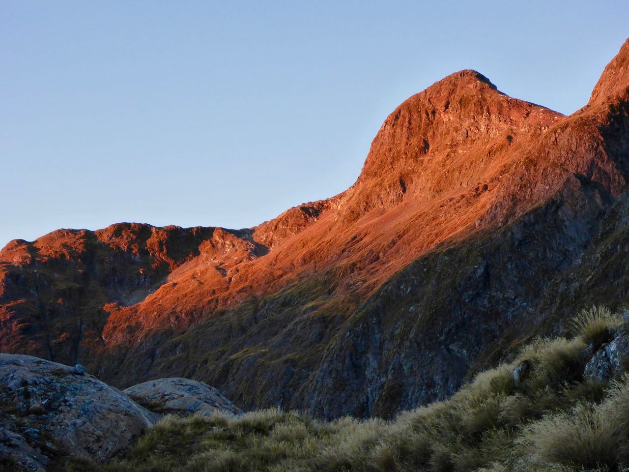
Our campsite was Arcadian with a spectacular view of the next lake and a cataract falling from lake 1100m. It was absolutely calm, the sun warming us, the only sound a distant susurration of falling water. Gavin got the Copper Hotel up while I made a hot drink. High above us was peak 1566m that B and I had sidled around at Christmas. Gavin assured me that it was an easy circumnavigation around to the lake below us to the next level.


Another clear sunny day greeted us the next morning. An ephemeral, red alpenglow crept across the surrounding peaks as we prepared to leave. An easy tramp around the lake took us to the tussock slope leading to lake 1100m. Here we launched our packrafts at the stream outlet and paddled up the still waters to a gully near the head. The lake was windstill with unblemished reflections of the surrounding peaks.


We landed easily, rolled up the packrafts and started up easy rocky slopes towards the ridge crest about 400m above. We moved swiftly with smooth, measured steps up the slopes away from the grey break cold into the warm, life-affirming world of sunlight and hope. From the stony saddle, we looked into a hanging valley to the NE with several tarns and shadowed ranges beyond. This was our Rubicon; no touring back once we descended into the valley ahead of us; no plan B. “Columbus had no plan B when he set out for the New World in 1492” I reassured Gavin. He did not reply. We cruised down and then left to reach steep tussock slopes dropping into the North Branch of the Florence. Then the slopes dropped away into vertical bluffs but hidden terraces led us down to the scrub line. The final push to the valley floor was little fun through tall tangled scrub down near-vertical slopes and cliffs.


(Photo by Gavin)

Once clear of this it was an easy walk up the valley to more bluffs. I vacillated about camping below these but the sites were not appealing so we climbed about 150m up open tussock slopes to camp on top of hill 1057m in a spectacular location. I was whacked so glad to stop. The view of our next pass looked straightforward. During the night the wind got up and persisted until dawn.
We knew the next day’s travel would be long and uncertain so got ready in the false dawn and away early. It was an easy 300m climb to the next pass. Down below us a small lake scintillated in the rising sun. The descent was fine all the way to Lake St Patrick. By now we were both “scrub-a-phobic” so after carefully studying the map decided to head left 1000m to avoid a band of scrub leading down beside the stream in the valley that we were following. This proved an excellent paragon, a clear descent.


It was cool with a northerly wind blowing down Lake St Patrick, so we decided it would be faster just to walk around this rather than a paddle. Ahead we could see the next pass to the west of Mt Watson, which looked easy enough. We stopped for lunch at the head of the lake and then it was a 2 km plod through waist-high tussock to the start of the next climb. The climb thankfully was an easy 150m climb to a hanging valley with a small lake. At the entrance was a huge white boulder that had recently fallen from the cliffs above that we thought might be white granite. It was quite striking. The wind eased off as we closed on the boulder slopes leading to the pass above. Clouds were filling the sky so we can sense a cold front approaching. From the pass, there was a rocky/tussock descent into the Diamond Creek, which we followed to the bush line. Here we sidled right and up to camp beside a small tarn on the shoulder below peak 1063m.


A tumult of swirling greys now filled the sky, lowering onto the peaks to the west and north like a funeral shroud. We quickly got the Copper Hotel pitched and dinner ready before the drizzle started. It lightly rained all night and stopped at dawn. We sidled further right until overlooking knoll 763. Gavin had loaded waypoints to this and further along the ridge down to the Spey. The bush was soaking wet as we spent 4 hours bush-bashing down to the Spey. We were soaked and our packs mud-splattered as we finally reached the Wilmot Pass road. Just then a Real Journeys bus stopped and the driver kindly offered us a ride to West Arm. Then he stared at me and said “ it’s Dr Mulvany” which had me nonplussed, as I did not recognise him. Once at West Arm, we boarded the ferry to Manapouri. The Real Journey’s lady took one look at Gavin and me and said: "You'll have to clean yourselves up". But how? We decided it prudent to stay outside so clomped up to the top deck for the trip across the lake where Belinda picked us up.


Acknowledgements: Thanks Gavin for a great trip. Thanks to Belinda for dropping us off and picking us up at Manapouri.
-->
1 comment:
It seems like an adventerous journey, thank you for sharing it with us.
compare airport parking
airport parking gatwick
Post a Comment