


I always knew this section would be tricky,
not only because the mountains are higher, but also because I would have some
big rivers and glaciers to cross. So it was with some relief when Reece asked
to join me for this section. He had work on at Omaramara and asked if we could
rendezvous at Mt Cook on 28th November.

I drove down from Geraldine to Unwin Hut on
28th and that evening Reece arrived. We left next morning in Reece’s
car to pick up Noel Carson at Geraldine and then drove to Mesopotamia. It was
blowing a Nor’wester as we drove up the Rantitata valley and we could see rain
ahead on the main divide. We only got a few kilometres past the station till we
came to Bush Stream, which was running a bit high. We decided to walk from there.


There is a 4WD track up the valley and we
plodded along this against a strong wind to Black Mountain Hut about 9 km away.
This belongs to Mesopotamia Station and permission is required to stay here. We
stopped outside it for lunch, as it was sheltered from the strong wind. Then on
we walked to Growler Hut another 7 km away. This was up a shingle fan past
Growler Stream and some Tahr hunters were in residence. Paul, the older North
Island man welcomed us in and his 2 younger companions did not appear till dusk.
They had all the creature comforts with them and no doubt thought we were doing
it the hard way. We had a good chat, then a meal and settled down for the
night. I had hoped to make Mistake Creek Hut or the Forbes Bivouac but the
strong wind was tiring to say the least.


We were up at 5.30 AM intent on making up
for lost time. We carefully tiptoed outside with our gear where we had
breakfast in the porch. There was a pile of meat hanging up drying. Dan came
out and kept us company, which was nice. He said they had seen 30 Tahr while
out hunting. The wind had died overnight and there was some cloud over the
valleys that later broke up with the sun. It was an easy walk up to the Forbes
valley, another 6-7 km further on. The Forbes cuts in near the junction and was
a bit tricky to cross. Once in the Forbes, it was an easy walk up the rocky
valley floor to the Forbes Bivouac situated in some bush on the TR. This was a
tiny 2-bunk hut and we stopped for lunch here. The sun was out and it was warm
and pleasant.


However we thought we should gain a bit of
altitude as Twilight Col is at 2194m and we were keen to reach the Godley Valley
next day. On we climbed to a nice campsite at 1100m with a view of Twilight Col
ahead. There seemed to be an awful lot of snow below it, and further on the
valley floor was full of big rocks and no obvious campsites. I suggested to
Reece we camp here and attack the snow slopes early next day, when they would
hopefully be frozen. Reece thought this was a good plan, so we lazed around in
the sun for the afternoon. Later in the day as the sun moved to the west, we
noticed a definite cornice on Twilight Col, which was a bit disturbing. C’est
la vie!


The following day we arose at 3.30 AM in
cloud and drizzle to an un-exciting start. We were pretty sure it would burn
off later so set off by headlight up the rocky creek bed. By the time we had
reached the slopes below Twilight Col it was getting light. We aimed for a
gully below the snowfields and here we struck old avalanche debris. It was a
slow grind up this to some loose steep rocks that led to the upper snowfields.
Reece had been plugging up the gully, so I took over for the plug up to the
cliffs above. By now the sun was out and the snow was softening by the minute.
On automatic drive and counting 50 steps at a time I reached the cliffs. Then
it was a sidle to the right into the couloir below the col. I was climbing up
increasingly steep snow when it turned to ice and with only 1 ice-axe I decided
it best to move right to a ledge and pitch the top section. Once on the ledge I
rigged up a belay and got the rope out. Reece then led up a vertical section to
the col using 2 ice tools. Soon I joined him for a glorious view of D’Archiac
to the north. Below us, Separation stream disappeared into the Godley and
behind us a sea of cloud covered the Forbes and Havelock valleys.


An easy slope took us down the Separation
valley to a boulder slope leading to the snout of Separation Glacier. From here
it was easier on rocky slopes down to the first vegetation in the valley.
Eventually we entered the wide Godley Valley and walked straight across it to
check out the Godley River. This was an awesome sight and clearly we were not
going to ford it. I had carried a packraft but we needed a gentle part of the
river to use it and none was present here. The original plan was to cross the
river and the other river coming out of Classen terminal lake to the Eade
Memorial Hut but I was too tired for the desperate struggle required so suggested
we camp down valley and sort out the Godley River next day and go up the
Rutherford instead. About 2 km down from the mouth of Separation we found a
nice campsite on the valley flats in the lee of a bank and set up camp. It has
been a hard day and I was glad to stop. The views were terrific of glaciated
mountains and clouds on their summits. Out of the cold wind it was very
pleasant as we brewed up a hot drink and ate some dinner.


On 2nd December we set off early
down valley looking for a crossing of the Godley. The first one was braided and
we thought it would go but several branches later, it was evident, we would not
get across. Then further on we saw a level part of the river where the current
did not appear to be too fast and where there was a good runout so we elected
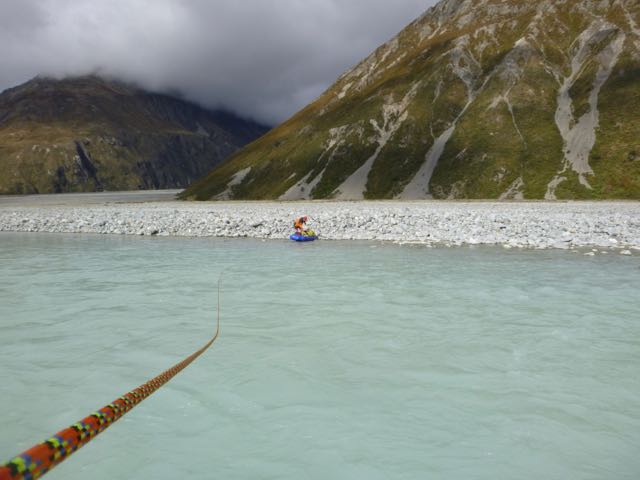
to try the packraft. I pulled it out of my pack and Reece blew it up. Then
after tying on my pack and the rope I set off for an easy ferry glide across.
Once over I pulled off my pack and threw the paddle in and Reece pulled it back.
It all went fine and soon we had the raft drying on some grass while we had a
bite to eat. Soon after we entered the Rutherford Stream, then the north
branch. We passed a dead Tahr. The valley is short and rapidly gains height. We
reached the waterfall where the snow starts. From there on it was snow
post-holing all the way to saddle between the Ant-hill and peak 2220. Reece did
all the hard work, as I was too tired from the previous days exertion.


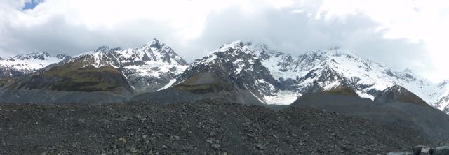
There was a great view of the Harper
Glacier on the other side, Coopers Mate and Mt Richmond. The route description
was to head due north and find a ramp down to the valley floor below. It was a
hot afternoon and there were lots of big surface slides in progress as we
descended the slopes to the ramp. We put on our crampons, as the ramp was quite
steep and exposed. Then we were romping down easy slopes to the valley floor.
At about 1800m we found a large rock where the snow had melted around it and we
camped here. Soon Reece had his green Minaret tent up while I put on a hot
drink. It felt good to have the second big crossing behind us and to know the
rest would go easily. The only niggling doubt was the risk of being taken out
by an ice avalanche from the Harper Glacier menacing the valley above us but I
reasoned there was little evidence of previous icefalls. No sooner was I zipped
up in my sleeping bag when there was a tremendous roar of an avalanche. “Do I
need to get out?” I said to Reece in a clam voice. “Yes, It’s a big one” he
replied. But it was to no avail as the zip stuck when I tried to undo it and
then Reece said it was OK. With that I drifted off to sleep!

We slept in till 7.00 AM next day. The sun
reached us at breakfast and then we were off. The snow was still soft as we
descended the creek. Lower down it descended loose moraine slopes to the
Murchison Glacier. Once down in the lateral trough we walked up valley a bit to
find an easy crossing out to the white ice. Then it was down this to the
moraine. Just below the Mannering Glacier we entered the bleak world of the “Murchison
Mordor”. “Beware all ye who enter” I knew this was not a nice place from its
woeful reputation and I was not disappointed.


It’s a vast pile of loose rocks and rubble
that constantly shifts as you walk over it and it goes on and on like “the song
that never ends”. And where is the best route? Goodness only knows! We lost track
of time in there as we scrambled up and down countless hills of rubble. On and
on we plod till I espied some terraces way out to the left and I fixed my
internal compass on them. Finally we arrived at Nirvana and could walk without
difficulty though by now my ankle was having the odd jab of pain. “ I think
we’ll have to make for Liebig Hut as it’s on the true left and I think it’s too
difficult to cross over to the Onslow hut side,” I said to Reece who was in
agreement. Ahead was the Murchison terminal lake with 30-50m high ice-cliffs
breaking into it. Traversing around the lake on the TL looked easier and safer.


Once past the lake we followed down the
left side of the valley across river flats covered in moss and low scrub.
Further down we could see something white, which we assumed was the roof of
Liebig Hut so made a beeline for it. Merde! As we drew closer it morphed into a
big boulder. “ Where’s the friggin hut?. I can’t believe we’ve passed it”. I
said in exasperation. We decided to divide our forces. Reece would go on and
I’d backtrack. After a bit of phaffing around we found it tucked in near the
hillside about 200m up valley. Being painted a dull green colour did not help its
visibility. But all ended well as we found an empty 6-bunk hut.


Reading the hut book, it seemed to be used
mainly by fly-in Tahr hunters. Very few manage it on foot! It’s infrequently
used and it has an interesting history. The original hut was built by the
forestry service in 1965 and in 1999 it was closed after an avalanche hit the
hut and it was due for removal. Then DOC received a bequest from the will of a
Western Australian man called Barry Anthony Armour of $49,000.00, specifically
for Liebig Hut, which ensured it’s survival. The hut was relocated to a safer
site 100m away and rebuilt by Doug Henderson. The interesting point is that no
one knows who Barry Armour was and what his association to Liebig Hut is. I’m
trying to find this out.
Liebig is a basic but comfortable hut and
its charm is in its remoteness and mysterious history. We settled in for a
comfortable night. At 7.00 PM we got the forecast on the hut radio linked to Mt
Cook, DOC base. They were surprised to know someone was in the hut and asked
for our details.
Off next morning we walked down the flats
to the Tasman Valley and had no trouble crossing the braided Murchison River.
Then it was along the moraine wall and river flats following the Murchison
River to its outlet into Tasman Lake. There were several Glacier Explorers
boats out on the lake. Reece wanted to head back to Invercargill that day and I
was not too enthusiastic in using the packraft to cross so I hailed one of the
tourist boats. Presently Will came over
with a load of tourons and said he’d come back for us once he dropped his
clients off. Awhile later he arrived and took us across. Then it was a short
walk to the car park at Blue Lakes where a German man, and his Chinese family from
Singapore, gave us a lift back to Unwin.


My car was sitting rather forlonely in the
car park out back. After thanking Simon, we drove up to Mt Cook village to pay
our hut fees, have a quick natter and drink on Charlie at the Mountaineers
café, put some money on the tab at the Chamois bar for Will and co and then hit
the road to Geraldine.
This last section has been the hardest to
date with 2 alpine crossings and some tough terrain. My appreciation to Reece
for joining me and for his great company.
Now I’d come half way down the Alps this
year so pretty pleased indeed. Many people have made it possible not only by
the support of Belinda but also with companions like David Waugh, Richard
Leppard, Reece McKenzie. Without all of you, I’d still be trying to sort out the
logistics.