

This trip has been on my radar for some time and I was
fortunate to have Gavin Sinclair join me for this mission. Gavin is a resourceful,
indefatigable backcountry tramper and packrafter, an ideal companion in the
inimical environment of the Waiatoto.
The Waiatoto is an enormous river arising in the Southern
Divide, draining the Volta Glacier and Mt Aspiring and flowing through some of
the most spectacular mountains in Southern NZ, to debauch into the Tasman Sea.
The route I planned was to ascend the Wilkin River from Makarora to Pearson
Saddle and descent to Bonar Flats and on out to Waiatoto Bridge. Gavin was keen
on the plan.
With an excellent forecast, I left early on Thursday morning
25th January 2018 for the drive from Invercargill to Arrowtown. The
roads were quiet as I sped north and by 8.30 am, I was at Gavin’s place. Then,
we drove in convoy to Pipsin Creek at Makarora, where we dropped by to say
hello to Christine and Grant, who are building a house there. After a short
pause, we continued on to the Waiatoto Bridge where we left Gavin’s van and
drove back to Pipsin Creek to park my car there before walking down to the
Makarora River. From here, we packrafted down the gentle river to the junction
of the Wilkin River and walked up the true right bank, in the evening sun, to
camp an hour in on a pleasant greensward, beside some willow trees.


It was a hot quiet night and we awoke to an umbrageous dawn under
heavy clouds hanging on the surrounding peaks. It was warm and humid as we
lumbered up the flats under our massive packs. Too soon the clouds dissipated
to a roasting hot day. We stopped several times to wet our shirts and hats in
an attempt to cool ourselves. Gavin complained of a sore little toe and when we
inspected it, at one creek stop, we found it infected and exuding pus from a white
hole. Once we had aspirated the gunk, he felt much better. Then I put on some
leucoplast and started him on a course of Roxithromycin.
At Kerin Forks we met 2 DOC workers doing hut maintenance and
had a chat and lunch there. On we went to Top Forks Hut another 7.5 hours away.
We were both ready to stop there. As it appeared that 3 people were staying at
the main hut, we made ourselves comfortable in the old warden’s hut behind it.
Even though it was after 7.00 pm it was stifling hot. Later the others returned
from lake Diana, Lucidus and Castalia. One of them was Lois Martin, an
ex-Invercargill lady who had tramped locally with Tussock, Ron McCurdy and
others in the Southland Tramping Club. She told us of two friends who planned
to cross Pearson saddle shortly and asked us for up-to-date information on the
crossing.


By now our internal alarm clocks were set to wake us up at
5.00 am. By 6.00 am next day, we were away climbing up through bush to the bush
line. This was an ineluctable, wearying climb. We ascended up to the bush line
and then up through subalpine scrub. The valley fell away to our right and
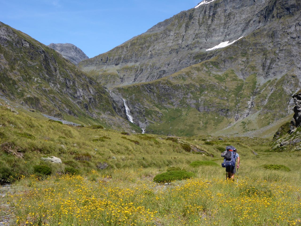
ahead we could see a hanging valley that we slowly gained. Then, we were
cresting a spur and looking into a hidden valley, gilded with golden tussock
curving around to the right. A little later the famous Waterfall Face hove into
view. I stopped and studied it – it looked exceedingly steep and the only
possible route appeared to be on the true left. However, I had a perspicacious
view that it would be fairly straightforward, which it was. The route was about
200m high and went up the true left of the waterfall to a spur. Then it was a
gentle descent over a rocky slope into the hanging valley under Pearson Saddle
and Rabbit Pass. We stopped for lunch on a flat and stretched out enjoying the
levitation after heaving our heavy packs onto the tussock. A salubrious fugue
suffused my being as I watched the cumulous clouds drift over the Divide. I had
some lunch. I felt better and ready to climb the last bit to Pearson Saddle and
peer into the fastnesses of Southwestland.


The saddle was wide and tussock-covered and flanked on
either side by the stark rocky peaks of Mt Taurus and Pickelhaube. I had been hoping
beyond hope for a warm tarn on the saddle, an epicurean delight in the stifling
heat and to my amazement there it was. Nearby was the perfect campsite and once
we had the tent up I strolled back to my warm pool. Gavin’s toe was sore again
and needed some attention.
The route to the Waiatoto lay to the Southwest below the
Beauty Ridge. Moir’s Guide suggested climbing to 1500m to the south of the
saddle and sidling above 1400m under the cliff line aiming for a corner on the
west. We had a lovely warm night in our tent and we left early next day. It was
a 100-150m climb at first up a tussock hill and then a descent to a waterfall
where we struck up left again to a large terrace under a major cliff line. We
worked our way across this to a corner where there was a rocky buttress and
climbed up to the left of this to a spur with a huge drop off to the right. It
was a 100m ascent to a tussock terrace that ran westwards for about a
kilometre. Here there was another spur and once crossed we could see the head
of the Waiatoto, Lake Bonner and Mt Aspiring.
Below us we could discern a tussock shelf that appeared to run towards
the bush spur to point 704m. A chamois bounded down the slopes below us.


The descent of this though steep was straightforward. The
bench sloped off to the left and took us down through steep subalpine scrub to
the bush line. It was stiflingly hot and muggy and I felt weak and drained at
times. In the bush at first it was easy enough on deer trails but beyond point
704 these eventually disappeared and we had a strenuous bush bash down the
lower few hundred metres to the river. More than once I muttered, more to
myself than Gavin, “dear God will this ever end?” A flash of wings and a bush
robin on matchstick legs grasping a nearby branch regarded us with curiosity,
the sunlight reflected in its black eyes. I felt better! On we stumbled and
crawled our way down through tangled bush and lawyer vine to the river flats
where we stopped on a flat sandy beach shaded by some trees for a breather.
It was another few kilometres down to Bonner Flats so we
shouldered our packs once more and pushed on. However, the river ran in tight
against the true right bank and we were reduced to scrambling-crawling up and
down steep densely choked bush-covered cliffs – an exhausting, acerbic trial
late in the day. After this lugubrious effort, we reached the promised land of
the Bonner Flats and a lovely moss-covered area where we pitched camp. We’d
been 12 hours on the go. I was drained!


It’s amazing what some food and a good nights sleep can do
for your weary body. So with some alacrity, I jumped up early next morning before
the sun reached us. We quickly got breakfast, dismantled camp and off. Not long
afterwards, we could see the river now flattened out, flowing through the
extensive Bonar Flats. Here we launched our packrafts and paddled down for
several kilometres till the bush closed in again. Then we tramped down the TL
towards Drake Flats until we came to another section of river where we again
took to our boats and continued on to the flats. A strong wind blew against us
so we had to paddle hard to make any progress. At the bottom of the flats, we
pulled in to the left bank and packed up our boats. We were shocked at the sea
of Ragworth and Scotch Thistles densely packed on these huge flats - a hundred
years of improvidence and neglect of our remote lands. Casting around it took
us a while to locate the cattle track that runs down the TL to Axius Flat. Once
on it, we made good progress but it was hard work in the heat and muggy
conditions. I was talking to Gavin about not seeing any deer despite lots of
tracks when turning a bend we saw a hind close by. She studied us for a while, and
then trotted into the bush. Somewhere near Ferny Flat we came across the frame
of a camp, a rough table and a few sheets of iron and set up camp. It was a
damp place and for the first time on this trip, the sandflies were a bit
annoying.


At 6.00 am next morning, a low flying helicopter coming over
our camp and heading down the valley wakes us up. “Might as well get up” I
exclaimed after it passed. A while later while tramping out in the open, it
returns carrying a few deer on a strop underneath and heading down valley
again. We sort of loose the track on an open creek bed but shortly afterwards,
we see that the river is now broad and flat so we inflate the boats and set
off. It’s so nice to paddle – no pain and good gain with minimal effort. Axius
flat is easy till we near the end where there is a rock garden. We land on the
TR and pick up the track there. However a bit further on we pass the rock
garden and it again looks easy so we’re back on the river for awhile until we
hit another rock garden and make a quick ferry glide to the right bank to avert
disaster. From here we tramp on to Casey’s Flat and stop for a spell at the hut
there. 2 brown horses eye us cautiously as we pass.


We get Carol’s weather forecast on Gavin’s InReach and she
warns us to get out soon as a storm is on the way. It’s 2.5 hours to the bend
and another hour to Long Beach. However, just as we’re cruising along the track
not far from the end, we bump into Wayne Allanton and Caleb who are out track
cutting and who have come up in their jet boat. “Where have you guys come from”
Wayne exclaims. “From the Wilkin and Pearson Saddle” I reply. Wayne is clearly
impressed. “How did you cross the river?” “I’ve got a packraft” indicating my
pack, I reply. “You must be very fit. Would you like a lift across the river?”
“Yeah, that would be great”.


So Gavin and I tramp on down to Long Beach and we’ve only
just arrived when we see Wayne backing his jet boat out of a beach further
upstream and comes down for us. We’ve
already decided that we’ll take a lift to the Waiatoto Bridge if he offers a
ride out. He does. It’s just another 3 hours of either foot slog or a paddle
around lots of “tree strainers” and “deadheads” in the last bit of river so
we’re more than pleased to get the lift.


Then, it’s a drive back to Pipsin to pick up my car and have
a yarn and drink with Grant before we continue on to Arrowtown.
Acknowledgments:
My thanks to Gavin for companionship and his expert navigation. I could not
have done it alone! Thanks to Grant and Christine at Pipsin Creek for your
hospitality and help and lastly to Wayne and Caleb of the Waiatoto River Safari
for your generous lift out.