The
Mingha-Decepton Valleys

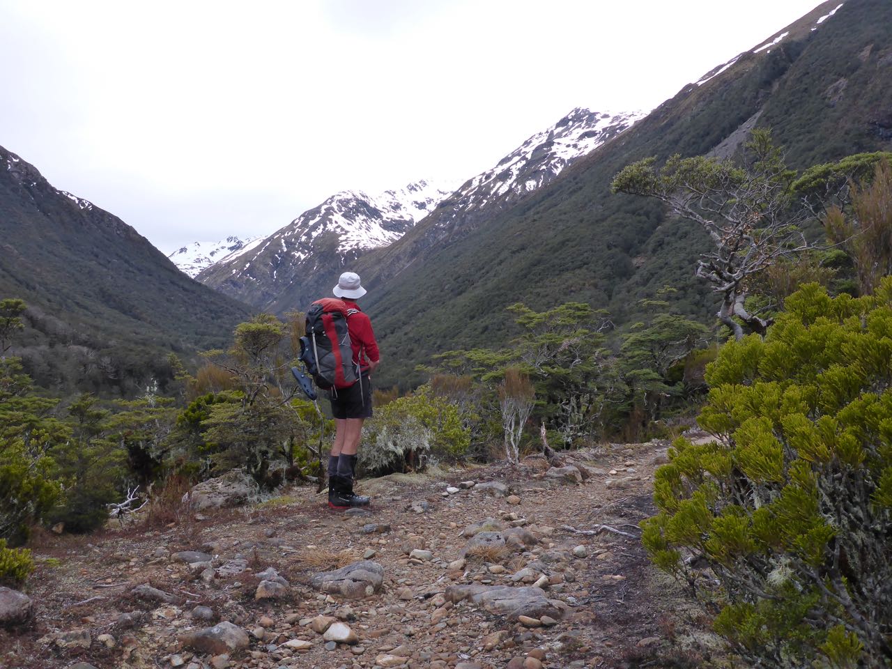
Last summer/autumn I travelled from Lake Rotoiti to Erewhon Station at the headwaters of the Rangitata River in mid-Canterbury but I missed the Mingha-Deception tramp. This was part of my Southern Alps Traverse, which I started this year. This spring was exceptionally fine weather, so I decided to head north and do the tramp, on my way to Nelson. On 30th of September, Belinda drove me over to Greyneys early in the morning from our camp at Aichens. I had no difficulty in fording the Bealey River and soon I was walking up the side of the Mingha among red-lichened boulders under an overcast sky. In less than an hour, I reached the bush edge. From here a track climbed steeply on the true right of the valley through the forest to Dudley’s Knob. The views were of extensive beech forest on both sides of the valley rising to snow-covered tops. Ahead I could see veils of rain sweeping across Goat Pass.


From the Knob
there was a descent, followed by easy walking through forest to the small
historic Mingha Bivouac. I made a hut entry here and carried on. Just past the
hut, I met 2 old grizzled trampers and a boy. “Hello, how’s it going” I
ventured. “What’s your name” the younger one replied. “Stanley Mulvany” I said.
“Never heard of you” was the gruff reply. “I’m from Invercargill,” I said.
“Where’s that?”. I thought it was time to leave, so bidding them a safe journey,
I carried on. Once past the bush edge
there was a climb on boardwalk to Goat Pass at 1070m. The views were a bit
limited by the thick cloud cover on the surrounding peaks. A steep descent
brought me to the palatial Goat Pass hut just below the pass. It was empty and
I had a brief stop as it had started to drizzle. The Deception has a reputation
for holding up parties by flooded rivers, which I was acutely aware of.


For the next 100m
of descent, the track was a steep creek bed, which was poorly marked and had me
in some doubt, till I came across the occasional markers. The rocks were wet
and slippery so I took it carefully. There were many creek crossings lower
down. The river grew in volume as more tributaries joined. Then the route
became more of a track on the TR and I came to Deception Hut in a clearing. It
was still drizzling so I had a quick lunch and pushed on. Just past Dorreen
Creek, the valley opened out with wide benches and flats on both side and I
flew along. There were occasional sections of gorge where I had to boulder hop.
In the distance I could see the Otira Valley and the last spur on the TR of the
Deception. One last ford and I popped out onto the gorse and broom flats
leading to the Morrison footbridge, which I crossed just under 9 hours after leaving
Greyneys. Then it was a 30-minute walk along the road to Aichens to find a
surprised Belinda in her camper bus.

Mt
Owen 1875m


Mt Owen is unique in New Zealand in that it’s formed of glaciated karst. It’s composed of amazing formations of glacier polished marbleized limestone. It’s like a glacier that been fossilized or turned to stone by the strike of a wizards staff. In fact one of the scenes of “Lord of the Rings” was filmed here, Dimrill Dale. Beneath the mountain is the Bulmer Cave system, New Zealand’s largest. There are many unique plants that only grow here.
Mt Owen is a
popular mountain to climb and most ascents are made from the north from Granity
Hut. There is an unsolved mystery here that started in December 2012 that I
kept hearing about. A recent edition of the NZ Geographic magazine tells the
story of the disappearance of Alistair Levy, a Palmerston North high school
teacher, who vanished on 23 December 2012. That day, 2 trampers, on the
northern slopes of the mountain, last saw him.
He was headed for Bulmer Creek on the south side of the peak, and
vanished without a trace despite an extensive search. I’d read enough to know I
would need to be extra careful on this solo trip across this mysterious
mountain.
On 8th
October, Belinda drove me from St Arnaud to the Owen Valley East road to the
start of the track up the Owen Valley to Sunrise Peak. It has been raining a
lot and was forecast to clear that night. “Are you sure you want to do this”
Belinda asked me on the drive over as rain fell on the peaks around the Buller
River. I was wondering about this myself but all my instincts told me to tough
it out, as the forecast was for a clearance. I started at 6.30PM and walked up
a sodden track for 45 minutes before camping on a wide part of the track. It
was a pretty dismal scene as I pitched my Mira 1 tent and settled down for the
night.
Next day, I was
packed up and off by 7.15AM. The track soon crossed the creek and from then on
my boots were wet, a NZ custom that overseas trekkers find unusual, till they
realise there are usually numerous river crossings and some are tricky across
uneven river boulders. Just past the junction of the Owen River and Bulmer
Creek, the track crossed the river again to the TR and then climbed steeply to
the bushline at 1250m. The day was cloudy with sun breaks and improving all the
time. The route then followed a sharp spur, sidled right and upwards to a gully
that led up Sunrise Peak. Bits of red flagging tape on broken bamboo sticks and
vegetation marked the route, rather poorly. Once on the ridge it was a short
walk to Sunrise Peak at 1583m. The views were pretty good though I could not
see the top of Mt Owen to the north. To my left I could see Castle Basin that
led to Bulmer Creek, Alastair’s last route. It looked very rocky, but not that
difficult at a distance, at least.


My route was now
along Sunrise Ridge. This was a rocky limestone ridge riven with cliffs and
sinkholes. Luckily it was cairned so I made slow progress along it towards Mt
Owen. At times I lost the route and had to fossick around to find the next
cairn. Just under Mt Owen the route veered left and then up the west ridge to
the summit. There were a few tricky spots on cliffs and crevasses but nothing
too difficult. I did drop my pack to scout a route up some cliffs to the
summit. There was quite a bit of snow around and I thought I might have to back
track and head around the west side of the mountain. However on the summit,
tracks led northwards to follow a line of cairns so this was the obvious route.
I quickly climbed down to retrieve my pack and carry it over the peak. The
descent followed a series of snow gullies along footprints in soft snow, which
led to a curious area of marbleized karst with ledges and crevasses. Once past
them I stopped for lunch spreading out my damp gear on a huge flat ledge and
enjoyed the sun and quiet. I was so hungry I ate my 2 sandwiches with relish.


Further on I
passed some tarns and contemplated having a swim but time was marching on so I
did not delay. The track was now more defined across tussock valleys and passes
dropping to Sanctuary basin. Finally I crested a rise to see Granity Hut below
me. Here I met 2 trampers who had just climbed Owen and it was their footprints
I had been following. The hut was spacious and much more pleasant than the
previous nights bivouac.


Next day I awoke
to a frost so was in no hurry to leave. Belinda was not due till the following
day at Courthouse Flat so I was undecided what to do. The other 2 occupants
left and then I decided to carry on myself. It was a leisurely walk down Ghost
valley, then up the ‘staircase’ to the saddle just north of Billies Knob. There
was a campsite here at 1250m in a gorgeous location and just south of me was an
easy slope up Billies Knob. Although there was no stream, there was plenty of
hail on the ground, which I could use for water, so I decided to camp the day
here. The sun was beating down and it was warm and the bush to the west
sheltered me from the cooler westerly wind. Tuis were chirping in the trees and
an inquisitive weka paid me a visit. On the ridge to the south rock trolls
stood guard. It was all rather surreal and peaceful. I pitched my tent and
after lunch, I set off and climbed Billies Knob. Great views all around and I
took lots of photos. To the north the Patriarch marked the southern terminus of
the Wharepapa Arthur range, my next goal. The following day it was an easy
descent down to Courthouse Flat and further along the road Belinda arrived in
the car, to whisk me over to a café in Tapawera.


Wangapeka to Cobb Traverse

The initial plan
was to traverse the whole of the Wharepapa Arthur Range from the Cobb along the
tops to the Wangapeka valley but unsettled weather and lack of a companion made
this a risky undertaking so I opted for plan B. This was to follow the
Wangapeka Track and cross over to the Karamea/Leslie Valleys to the Mt Arthur
Tableland. Due to an unexpected turn of circumstances, I ended up doing a
combination of both these trips.
On 15th
October, Belinda drove me from the Cobb, where we had been camped, to the
Wangapeka/Rolling River junction. It was early evening and at the concrete
bridge below the junction we saw a notice saying the road was closed. “Strange”
I thought. That was not here a few days ago when we drove out and the road
looked fine on this sunny day. On we drove till a white truck blocked the road.
Behind it a helicopter was hovered and a lot of people clustered around it.
“What on earth is this about?” I thought as I hopped out to meet a young guy
strolling towards me. “The road is closed and no one is allowed entry” he said.
“ What closed? But I need to head up the Wangapeka today as I’m on a tight
schedule.” I replied. “I’m sorry but we cannot allow anyone through. There is a
1080 operation in progress and the track is close till tomorrow night.” “Can’t
you escort me through?” I countered. It was a ‘no go’ so we turned around and
drove down the road. I was furiously thinking how I could get around the road
block and the only logical option was to ford the Wangapeka River and head up
Chummies Track and go along the tops. In fact this was my original plan so I
had already researched the route. The bit I did not like though was fording the
rather large Wangapeka River by myself.
We stopped and had
a look at the river opposite the sign marking the start of the Chummies Track.
It did not look great but I thought I’d give it a go. Loading up my pack, I
gingerly waded out but less than half way, I was too scared to make it across
so I retreated. Then I tried it higher up with the same result. Next we drove
down the road a bit and immediately I saw a quieter stretch of the river so
asked Belinda to stop. I’d try here instead. Thankfully I managed to cross
safely and walked back up 100m to the start of the track to the John Reid Hut.
Signalling B to wait, I scouted the track and once convinced I was on it headed
up the hill. It was now 5.30PM and with not a lot of daylight left, I climbed
rapidly up to 725m where I found a nice level stretch of ridge and a nearby
soak. The evening was calm and clear as I set up my one-man tent and cooked a
meal. Then I studied the maps and decided on a plan for the next day to
circumvent the 1080 operation.
I awoke at 6.00AM
to a windy day and SW cloud covering the tops. I was fired up to go and did not
bother with breakfast, as I wanted a quick get-away. It was a long pull up
Chummies to the bushline at 1250m, then a sidle out to the left to the John
Reid Hut. This was a small 6-bunk olive green hut and inside were 3 people. One
of them was a DOC worker who was surprised to see me. “Do you know there is a
1080 drop underway and you should stay here” he said to me. “Yes, I know but I
have a long journey in front of me and I have to keep moving.” I replied.
“Well, I cannot stop you but you should not drink from any streams or open you
mouth when they are dropping the pellets.” He ventured. “Yeah, that’s OK. I did
not come down in the last shower” I reassured him and with that I carried on.


It was a 200m
climb to the ridge crest above and then I traversed some rocky peaks to the
Southwest towards the Patriarch. There was a stiff cold wind blowing over the
ridge so I did not linger. In places the ridge was narrow and exposed and care
was required. I figured the 1080 drop would have to be postponed as it was too
windy. Further on I came to the poled route down to Kiwi Saddle Hut. It was
much more pleasant in the bush and sun breaks warmed the air there. It was a
500m drop to the lovely hut on the saddle. I got there at 1.00PM after 7 hours
on the go and finally had brunch. It was so nice to brew up a coffee and take
it easy for an hour.


By 2.00PM I was on
my way to Luna Peak on a well-marked track. Above the bushline, it followed an
increasingly exposed spur and then dropped off it on the right to sidle to a
col just north of peak 1578m. The day was overcast by now and the air
temperature low. I took a GPS reading to make sure I was on track and then
dropped down into Stone Creek, which I followed on a disked trail all the way
to the Wangapeka River and Stone Hut. So much for not drinking out of rivers
after a 1080 drop. . . there was no water tank at Stone Hut! The plan for the
next day was to make Venus Hut.


On 17th
I got away at 6.40AM on the gentle climb to the Wangapeka Saddle. The valley
narrowed in as I started to climb and I slowly gained height as I was tired
from the previous day’s effort. On the saddle was a signpost and I turned right
up to the Biggs Tops on a gently graded track. Above the bushline was a track marked with
blue poles heading north and west to the Karamea Valley. The saddle was at
1320m and from here there was a steep descent of nearly 800m to the floor of
the Karamea River Valley, where I reached the Trevor Carter Hut. This was
situated on a river terrace and was empty. The sun was shining and it was so
peaceful I felt like staying the day there. However after some lunch I carried
on. It was a 4 hour walk down the valley to Thor Hut and another 2 hours to
Venus Hut which I reached at 6.00PM. The hut was again spacious and empty.
After a hot drink, I had a bath outside and felt much better. I washed some
clothes and hung them on the verandah. I had an early night as I planned
another early start next day.


It was a relief to
see the weather was still fine. I was on the trail by 6.45AM. Just outside the
hut was a swingbridge across the deep slot of Venus creek. It was an easy walk
along to Jupiter Creek, again a deep slot and further on I crossed the Karamea
River, on a high swingbridge, to the TR bank. The track climbed up onto a
terrace that was very boggy for a long way before descending to the river bank
and better going. Then I came to Crow Hut, to a welcome by 3 fishermen staying
there. Trevor was a GP who specialized in remote posts overseas, and his
friends were Paul and Nick. They trust a cup of coffee into my hands and I
chatted to them for half an hour. Then it was on to Karamea Bend Hut where I
stopped for lunch. From here it was an easy walk up the Leslie on a good track.
Once past Arthur Creek it was a long climb to 790m to Splurgeons Rock Shelter.
My feet were rather painful by now and I was glad to stop for the day. Splurgeons
is situated on a rock platform above a cliff in the bush with a great view of
the surrounding valleys. It has tin sides and a plastic front that can be
rolled up. The floor is earthen. It was good to have a hot drink and some
dinner. The weather looked a bit ominous so I planned a pre-dawn start.


My sleeping
patterns are often erratic in the mountains so I often take a sleeping pill and
I did that night. I was worried about the weather and woke up early. The moon
was shining through the plastic wall casting an errie glow inside. I checked
the barometric pressure and noted it had dropped overnight. Outside cloud
covered the tops and there was a freshness in the air. I got away before dawn
by headtorch. It was a 400m climb to the bushline. The track was well graded
and easy to follow. The birdsong I noted was great and included a moorpork and
tuis and other birds I could not identify. A weka pranced along in front of me for
awhile. When I eventually reached the Arthur tableland the long tussock was dripping
wet and thick mist covered everything. I was not entirely sure where I was so
got out my GPS, which confirmed I was near the branch track to Salisbury Lodge.
It was a long trudge across dripping wet tussock in mist to Balloon Hut where I
stopped for some food and got on my wet weather gear. On I plodded following
the poles to Lake Peel. From here the track swung east, up and over the Cobb
Ridge where the sun came out and where it was much warmer. A gentle track
dropped to Myttons Hut and the Cobb where I found Belinda in her bus/camper.


