Saturday, April 13, 2013

Ailsa Mountain Traverse


The idea to do a traverse of the Ailsa Mountains was first mooted by Mike Dunn though I’ve vaguely thought of doing it for many years. A few of my friends have visited it in the past including Bill McLeod and Jon Taylor and spoke highly of the area. Oddly enough little is written of this range of alpine peaks though thousands of trampers walk past it every year.

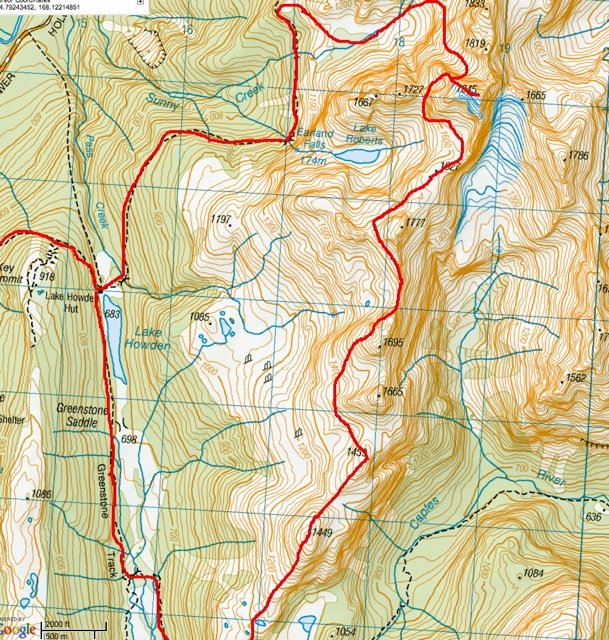
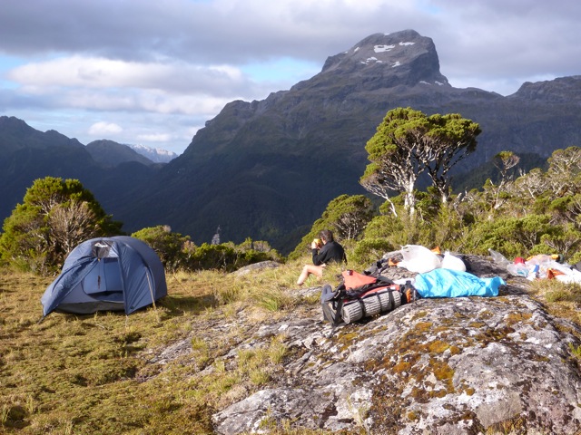
On the weekend 26/27 January 2013 Beth Masser, Ceri Hutchinson, Reece McKenzie and I set off to do a traverse of the Ailsa Mountains. This trip proved to be full of interest and quite challenging. An early start was made from the divide and the party made for McKellar Saddle. From here we struck up onto the range, climbing peak 1449. Further on were two peaks 1665 and 1695 meters that looked loose and uninviting. These were traversed on the Hollyford side and the ridge gained beyond them. Ahead peak 1777 was sidled by a col to the west that took them into a valley above Lake Roberts. An upward climb took us to a broad ridge dotted with tarns and a comfortable bivi site to the north of the aforementioned peak. Ahead peak 1945 meters looked very difficult of access by the south ridge. In the evening 2 chamois were noted to be racing across the summit ice fields of this peak. We had splendid weather and great view especially towards the Darran Range.

Next morning it was decided to make for a breche to the west of peak 1945. Once gained the party found a massive drop off down the gully to the north so after a reconnaissance climbed up about 35 meters onto a ledge curving around to the north and found that an abseil would take us onto a terrace around the corner. Once down it was a straightforward upwards climb to a ridge overlooking Sunny Creek. There was a steep drop off to it however. The packs were left and an easy rock scramble led them to the summit of the highest peak in the Ailsas. There were fantastic views all around. To the north peak 1902 had a glacier running off it to a lake in a corrie to the south.

A quick descent was made back to the packs and 2 abseils down a cliff face took them into a hanging valley above Sunny Creek. An old piton was found half way down the cliffs that someone had obviously used in the past to rappel this route. Later we saw a chamois dashing up the route the team had just descended! Lower down we had difficulty in finding a route into the lower valley due to a wall of cliffs below us. Eventually a way was found off to the right and an easy walk down valley to join the Routeburn Track and a fast walk out to the car.


On Friday evening 5th April Matt and I drove down to the Divide and walked in to the mouth of Sunny valley in the dark and flogged our way up through the bush to camp above bushline. It was frosty and cool. We started next morning at 8:30 AM following up the deer trail in Sunny Creek. Further up the valley was a large, very large stag slowly making his way up. He stopped and surveyed us for awhile and it was only when in profile we appreciated his huge size. At the top of the valley we moved left up to a col between peak 1620 and 1889. There was fresh snow on the ground, just a light covering. At the col we turned right up easy slopes to a rock band that was easily climbed to boulder slopes to the summit. 


We summited peak 1889 at noon. The traverse to peak 1902 looked desperate "a Mordwand". This peak I've named 'Glacier Peak' as a glacier  ( the Stanley Glacier) drains south to 'Lake Matt'.  We descended the same route back to the col and then tried to traverse along to the plateau under peak 1744 but the route was cut off by a deep ravine over 100 meters deep. Returning back towards the col we descended to valley floor into the bush and dropped about 200 meters onto the track just before MacKenzie Hut. From here it was a fast walk back to the car and drive to Homer.

We still have not finished the complete Ailsa traverse. On the map I’ve marked in blue the route I want to take next summer to complete the full traverse. The Ailsa Mountains offer an excellent high mountain traverse with interesting route finding and some difficult climbing thrown in. I suspect in time it will become a classic mountain traverse.

Tuesday, April 2, 2013

A Journey to Mt Hooker


Mt Hooker is one of those mystical peaks that occasionally appear under its veil of storm clouds as one drives through the Haast at the Landsborough confluence with the Haast River. It seems to float in the sky, an immense whaleback of ice and rock. It has long been a desirable goal and my plans have been dormant for many years. But recently the opportunity arose to take some friends on a trip up the Clarke River to Marks Flat so a trip was born.

On 18th February Paula, Matthew and I left Invercargill bound for the Haast. At Lumsden we picked up Boris, a visiting Russian/Israeli climber and continued northwards. At Makarora we stopped for a drink and then over the pass to Pleasant Flat where we took the gravel road on the right just before the bridge. I was not sure just how driveable this was but unfortunately DOC has not maintained it and we had to leave the car after a short distance.


The day was fine and hot as we shouldered our packs for the 2-hour slog to the old homestead. On the horizon floated the massive form of Mt Hooker. We had a breather at the homestead before pushing on to the Landsborough River. With remarkable foresight we carried a packraft with us in case we needed this for the river crossing. Arriving on the bank of the river I noted it was very wide and the water clear enough to see the bottom. We linked up in a line for river crossing and just made it across.  Then it was a short walk to the Cron’s Hut. This was locked but in any case it was too early to stop. We hid the raft in the bush nearby and continued on to Rabbit Flat where we crossed the river and camped at some lone beech trees on the flats.

The evening was lovely and the sandflies not a problem. Once the tents were up we lit a fire on the gravel riverbank and boiled the billy. There is nothing like a hot chocolate at the end of a long day tramping! During this a rather large spider paid us a visit causing some anxious moments! We had an early night and pleasant sleep.

Another fine day greeted us as we broke camp. The flat soon petered out into a rocky beach as we carried on up the true right of the Clarke. Another flat took us to the start of a gorge as we scrambled up large rocks to the start of a bush climb. Here the route goes up a sort of valley over a saddle to Davies Flat but it is not marked and hard to follow. Instead we climbed over a small peak 497 meters and descended on the north side of this to Davies. After crossing this small flat we followed along the river and into the bush for another climb to avoid a second gorge. This time it went more smoothly as the ridge was more defined and we descended easily to the start of Munro Flat. This extensive flat leads up to the junction of the Clarke coming down the Gorge from Marks flat and Saddle Creek coming in from the east.

Right at the junction we camped beside some beech trees in an idyllic spot. I went off for a bathe in the river and then we washed and dried some clothes. Again I lit a fire in the riverbed and boiled the billy. We studied the route description of our two routes, the Gorge route or Saddle Creek route and I decided we would take the Gorge route.

Next morning we crossed Murdock Creek and continued on to the Clarke. Once there we followed up the true left bank gaining height and staying about 60 to 80 meters above the creek. This rose steeply and we seemed to be climbing straight up most of the way. In places deer trails were a great help. Finally we reached the slip mentioned in the guide. This is largely overgrown and the route description in Moirs guidebook was inaccurate. In fact we crossed much higher than the guide suggested. We struck a rocky spur in the centre of the slip and followed this upwards to the top of the slip where we entered taller forest that was easier to traverse. This was at about 900 meters altitude. Ahead we could see the creek levelling out into flat country but several very steep spurs blocked our route. It was easier to go over the top of them and finally drop off the back of the last one down to the open flats.
What a relief! We lay down on the green grass basking in the sun and admiring the huge flats stretching away from us. Then off we set to reach the bivi rock about a kilometre away. We reached a huge overhanging rock, the same one as in the photo in Moirs. How good to stop and have a hot drink and meal. Knowing we had a 1700-meter climb next day to the top of Mt Hooker we elected to take just bivi gear and go part of the way up the route.


After a leisurely rest we set off with light packs up through a rock strewn slope to an old moraine wall and on the far side climbed up a tussock ridge to a rocky flat area at about 1600 meters just below the Hooker Glacier. Here we bivvied in relative comfort. The evening was still and warm. Above us stretches away a huge glacier towards the rocky summits of Mt Hooker. It was here Matthew discovered his crampons missing.

Up early next day we packed up and I gave Matthew my spare bivi gear as he was going to descend back down to Marks Flat rock bivi to await us there. Above us was a rocky gully we climbed to a rock ridge running into the toe of the glacier. Once on this we donned our crampons and soloed up an easy angled glacier to the first snow where we roped up. Then I led up an interminable slope to the left of the rocky summit at 2500 meters. What a view of snowy peaks and the incredible view of Mt Dechen and its ice cap to the north of us.

Then it was a steep climb of an ice slope to the rocks of Hooker, along a rocky ridge to a ledge leading around to the north side. Here there was an ice slope leading away towards the summit further along. It did not look too easy especially with just one ice axe and the summit rocks none too safe either. After some discussion we decided it was neither worth the risk nor extra time trying to reach the summit so we headed down. The descent was uneventful all the way to the bivi rock where Matthew waited us. As it was later afternoon we decided we would have enough time to start for the Solution Range.

So after a brew and bite to eat we packed up and set off to the head of the flats. Nearing the bush there we spied an opening in the bush edge and found a dry creek bed provided an easy ascent route to the bushline. Here though we struck some alpine scrub and had to battle through this to reach the easier tussock above. A bit to the left we found a good place to camp. A wonderful clear sunset boded well for the morrow.

Another lovely day! There was no sign of life in the other tent when I got up so we had a slow start, then off climbing up top the ridge not far away. Here we could look down to the Landsborough and further along an easy tussock ridge stretching into the distance over a series of humps. There was an old deer trail on the ridge crest that made for easy going. In places the slopes were heavily eroded on the Landsborough with steep drop offs. Later we came to a part of the ridge eroded on both sides and very steep. Down below us we could see 3 chamois and their tracks in the scree. They were startled to see us and ran towards us for a better view and then bolted down the slopes once they realised we were humans. At first their tracks were easy to follow but then we arrived at a particularly rotten, dangerously loose part of the ridge. I went ahead and climbed a narrow exposed rock ridge and warned the others not to follow me and to sidle along about 50 metres below me on the Clarke side. Here it was hard friable schist with a covering of rubble and very steep. This went on for quite a distance till we pulled clear of it onto a tussock spur.

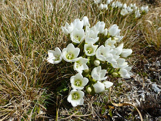
After this it was an easy climb along the ridges all the way to the top of Solution peak at 1710 meters. In the far side the ridge broadened out onto easy tussock slopes that continued all the way to the groups of tarns just before the bushline on the ridge. There was one steep descent off peak 1388 metres. Along this section were lots of flowers and great views of snowy peaks all around. The tarns were scattered on a small plateau surrounded by bush and very picturesque. We set up camp near them and went off for a swim in the tepid waters. The rest of the day was spent enjoying the surroundings and resting in this idyllic place.


We started in the dark next morning. Mist was covering the plateau as we tramped off towards the bush. We stopped on a small hill overlooking the plateau and it was like a scene from ‘Lord of the Rings’ with mist drifting over the lakes and an orange sunrise breaking over the ridge. Time to move on and down a steep bush ridge to peak 1042. Here we took a wrong turn in a small flat area and ended up heading back the way we had come till we noticed an unusual tree we had stopped by earlier on. Out with the compass to get a fix on Clarkes Mound and off again through fairly easy country. Further on though the ridge had lots of branches and it became more difficult to follow. We entered a nice open glade just before the climb up Clarkes Mound. This was steep and scrubby and eventually we reached open slabs with good views down to the Clarke River.


The ridge now swung to the SW towards some large rocks poking through the forest canopy. All around were giant boulders we had to scramble around and to the east was a big drop off to a creek running off to the Landsborough. Perseverance won the day as we started loosing height. At one stage we found some old markers on trees right on the ridge maybe put there in the deer cullers days. At about 700-meter altitude we headed off in a SSW direction down easy open forest and eventually reached the valley floor. I was following a deer trail on the descent and twisted my right knee that remained uncomfortable for the rest of the trip. We exited the forest a few kilometres from the Cron’s Hut and made for there. Here we picked up the raft hidden on the way in and Paula made me a hearty sandwich of cheese and Bier sticks, which fortified me for the 3-4 hour  walk out to the car.

Approaching the river we noticed a gravel bar on our side. It was hard to say if the Landsborough was higher but I think so. Linking arms we move cautiously across but at halfway point the river bottom disappeared into glacial blue water and I was scared we’d get swept off our feet so backed off. Looking upstream the bar headed right up to Strutt Bluff so we made our way up there. But the Bluff was unclimbable except for small cliff on the other side of a deep eddy pool at the mouth of the bluff. We blew up the raft and I paddled across with Paula sitting on the bow so she could cautiously step off onto the cliff and climb it to anchor a rope. Once done, I ferried all the others plus the packs over to the rope hanging down the cliff to be belayed up. Lastly I came myself, tied the end of the rope to the raft and climbed up and then dragged the raft after myself.

The rest was just a long plod out the car and a night time drive home arriving in Invercargill at 4.00AM I slept in the lounge for the rest of the night so as not to disturb Belinda. She was impressed next day!

A trip to Marks Flat and Mt Hooker up the Clarke River by Paula Macfarlane, Matthew Humphries, Boris Babaev and Stanley 18-22 February 2013

Saturday, March 23, 2013

The Gumotex 4 Expedition


In February 2010 Simon and I concluded our G3 expedition when we arrived in Milford Sound. Since then we’ve had a hankering to have another trip in Fiordland and the logical place would seem to be in middle Fiordland. Studying the map showed a lot of unknown country west of the Murchison Mountains and it seemed we’d have no choice but to retrace some of our steps for at least some of the way.

A look at the map showed a possible route from the Junction Burn Hut in the SW arm of the Middle Fiord to Lake Bloxham, over the tops to Lake McKinnon, down the Large Burn to Lake Marchant, Caswell Sound, Lake Shirley, over the Shirley Saddle to Marjory Creek and the Irene River. From there we could ascend the Irene River to the Irene Saddle, climb Coronation Peak and either go over the Te Au Saddle to the Forster Burn or alternatively traverse the tops to Esk Saddle and down the Woodrow Burn back to the Junction Burn Hut. Simon was keen so a trip was born.

We started on Monday 25th February. I drove to Te Anau and picked up Simon and headed to Te Anau Downs. Leaving our car at the Fiordland National Park Lodge/Motel we kayaked across a flat lake to the middle Fiord. Soon after entering the sound I heard the wind and sure enough a strong wind greeted us. Then it was an increasing wind we struggled into all the way to the start of the SW Arm. By now it was dusk as we raced to reach the hut before dark. It had taken us 8 exhausting hours to the hut.
I was feeling quite tired as I had just returned from a trip to Mt Hooker up the Clarke River and had done several other trips prior to that. In addition I had sprained my knee and it had not fully recovered.

But after a good nights sleep, I was feeling better as we set off up the Junction Burn. It was somewhat confusing to pick up the right track as the Woodrow Burn joins it. A short distance up the creek I noticed a yellow Personal Locator Beacon sticking out of a pile of drift debris. I put it in my pack and carried on. Further on we came to a hut and the track became more difficult to follow. Later we took a compass bearing and discovered we were in the Jennings Burn having missed the turn to the Junction Burn. A look at the map showed it did not matter as we could easily reach the mountains west of Lake Bloxham from the head of the Jennings Burn.

We were having lunch when I heard a loud beeping noise. Mystified I traced it back to my pack and to my horror found the salvaged PLB was flashing and sending out a signal. What to do? As we had no screwdriver, we could not removed the cover so Simon jumped on it smashing off the cover and pulled out the wires.  I had visions of a helicopter rescue underway for the errand PLB.


Once clear of the bush we ascended a series of rises containing lakes and then swung around to the right through a saddle to reach the upper valley above Lake Bloxham. Gaining the western Ridge we climbed up this to about the 1300 meter contour and then descended into a hanging valley above Lake McKinnon. From here it was a very steep descent down to the lake. In places there were cliffs but we managed to bypass them. At one spot I lost balance and nearly toppled off a cliff. After this we were more careful as it was no place to have an accident. Later in the day we reached the lake and stripped off to have a swim being so hot in the bush.


The lake was low and a white beach continued around the east side of the lake. The packrafts were inflated and we paddled down to the outlet. Unfortunately it was very muddy and wet in all the open areas so we paddled back up the lake to a stream and a raised gravel beach. Here we discovered signs of a recent helicopter landing and boot prints! We set up camp back along the creek in a sheltered spot.
We passed a very pleasant night camped under the trees beside a stream. I awoke early and lit a fire and boiled the billy. I gave Simon a cup of tea in bed and we had a leisurely start. After breakfast we carried the packrafts back to the lake and paddled down to the outlet. Here we beached and folded them up and set off along the banks through fairly open forest. Later we came to a slip where we could have a look at the surrounding mountains. In the middle of it was a palisade of logs probably an old hunters camp. He had a snack here before pushing on. The valley curved around to the left and we entered a strange area of open grassy and mud flats. There were signs of many deer passing through. At the lower end we scrambled across huge boulders and further on we were able to walk along many beachs as the river was quite low. Eventually we reached the river where Lake Marchant backfilled it. We paddled out into the lake to face a headwind.

I was a bit concerned by a strong breeze blowing up the lake but by keeping close to the eastern shore it was not too bad and we made steady progress along the shore to the far end. We passed a huge waterfall dropping into the lake off the surrounding mountains. Near the end of the lake we cut across to near the outlet and beached. Here we picked up disc markers dropping to Caswell Sound. Eventually we reached the lonely Caswell Sound Hut. This historic hut was built in 1949 by the Colonel JK Howard expedition on the NZ-American Waipiti Survey. It was repaired several years ago by Ken Bradley and Grant Tremain, when the roof was in danger of collapsing. I remember how glad we were to reach it in 2008 in a deluge after paddling in from Caswell Sound.


I lit a fire and got the billy on while Simon headed off for a wash braving a multitude of voracious sandflies. It was good to spread out our gear on the 2 bunks. In the hut book I read how my daughter Tara and her companion Sim had kayaked in from the sea two winters before at dusk and camped across the river and found it the next day. It must have been a welcome haven in the depths of winter. We had a hot drink and dinner and retired early.

After a restful night I awoke early but as it was still dark outside postponed getting up till dawn. We packed up and set off for the beach where the packrafts were blown up. I set off first, paddling onto a still sound. It was about 5-kilometers to the start of the climb to Lake Shirley. Simon passed me and headed off down the sound and I could not work out why he had gone so far out. Thankfully, he stopped so I paddled after him to point out the route to the granite domes below Lake Shirley. Landing, we packed up and set off and what a struggle. It’s a 600-meter climb to the granite domes and I felt exhausted by the effort. Lake Shirley is at 630 meters altitude and it took us several hours to reach it from the sound. It was a relief to reach the domes and then a sidle took us to the outlet of Lake Shirley.


Here we blew up the rafts and set off on the 2-kilometer paddle to the beach at the far end. What a lovely place, a sandy beach and a green swarthe for our camp. Once pitched I had a swim and then a brew up. Nearby was a Rata tree in full bloom with its red flowers adding to the magic of the scene.

It rained overnight and was drizzly at dawn. We had a leisurely packup and then I led off towards Shirley Saddle. A short while later we were brought up against a tall rock face. Here we moved leftwards and eventually found a green mossy steep watercourse that was easy enough to climb to reach the top of the cliff. Here on it was a steep bushy climb all the way to the clearings above the saddle. It seemed easier to avoids the saddle proper and instead head down into the valley to the south. Thankfully we found a good deer trail heading in that direction. Lower down we crossed the creek and moved down the left hand side to the main creek in the valley. Here we alternated between deer trails in the bush or walking along the river bed.  We had lunch in a nice spot and then continued along to the slip at the mouth of the valley.

This was a steep boulder slope dropping towards the Marjory Falls below. We remembered this well from our previous trip and at about 550 meters we climbed up a small cliff into the forest. Then it was down to the 500-meter level aiming for the spur running to the southwest above the falls. We had a lot of difficulty locating and staying on this as it offers an easy descent to the Irene Valley floor. Once down we walked across to the Irene River and noted this was tidal and rather large. The rafts were used again and we were delighted to find we could paddle upstream for several kilometres almost the site of our food cache. We were able to paddle right up to the base of the Marjory Falls that were spectacular. 


At the junction of the next large tributary from the north we knew our food cache was waiting. Leaving the packs at the junction we followed it upstream for a few minutes to find my orange flag and the buckets. Simon then found a nice place to camp in the forest about 100 meters along the Irene.
We set camp in a lovely spot on a high bank above the Irene. The tent was pitched and a clothes line put up and gear dried in the warm sunny weather. Then we had a hot chocolate to celebrate this milestone. Simon went off for a wander while I had a rest. We knew nearby were hot springs and Simon found a warm stream not far away. We had planned on a rest day next day and an opportunity to find the springs.

Another fine day saw us setting off unleaden upstream. We crossed the stream to a beautiful white beach and while there a helicopter suddenly zoomed overhead and although must have seen us did not acknowledge us at all. Futher on we came to the warm stream. Following this we found a small pool under a rock and lukewarm water here. It was only enough for one person to soak in and not very exciting. And that was it, no hot pools and no dancing girls etc. So back to camp where I did a tidy up and had a bath in the river. I lazed around the rest of the day and it felt very good.

Another fine day as we set off heavily leaden for the Irene Saddle. At first the golng was very easy as the river level was low exposing many beaches that made for fast travel. Here and there were small flats backed by beech forest rising up the steep mountain sides. At about 100 meters we entered the first gorge and we had to scramble up steep rocks. Our pace slowed a lot from now on. At about 300-meters we were forced into the bush and a very slow pace. Shortly afterwards I suggested to Simon we head straight uphill to the ‘Far Faraway Fields’. At first the ascent was easy but higher up was vertical in places. In one spot Simon’s feet slipped out underneath him leaving hanging on by only his arms and doing a face plant. Eventually wereached the Sylvian fields and set up camp in a lovely spot overlooking the Irene with views of Mt Irene to the northwest. The Far Faraway Fields is an extensive flat undulating clearing surrounded by bush, covering an area of maybe 25 hectares at 900 meters half way between Mt Irene and Coronation Peak. To the east the bush and scrub climbs steeply up to the ridge line. We had a pleasant dinner and retired early.
The plan next day was to carry all our gear up to the main ridge and set off on a day climb of Coronation peak to the west of us. The scrub was slow going and some steep tussock took us to some terraces to the ridge. Here we left our surplus gear covered in rocks as a kea sat quietly eying us. The day was fine though a bit breezy. A helicopter on deer recovery was buzzing back and forth into the Irene and landing deer on Te Au Saddle. At one stage it seemed to be having difficulty in clearing the saddle below us with several deer hanging off the strop. Ahead of us was a peak that we scrambled up only to find a very steep peak beyond that. The descent was not easy and we could have used our short rope to get down safely but I could see it was going to take a long time so was less than enthusiastic. So back to our gear and on to peak 1634. This was quite a climb and when we eventually got there we were surprised to find a loose steep ridge continueing over the next few peaks. It did not look like a packing route with our monster packs. About 100 meters below us to the east were snow slopes and rock terraces that we thought would allow us to bypass this part of the ridge.


This section was easy enough with several short rock scrambles and we reached the tussock ridge beyond the steep bit. By now bad weather was definitely on the way with cloud scudding the tops and the wind increasing. On we plod as fast as we could go. At the end of this ridge we could see a large lake directly below us and the slopes dropping very steeply. I raced off on a reconnaissance and found a good route down the lake. Once down we contoured around a small hill and as we were now in cloud and the day advanced we called a halt and put up the tent in a small depression in the lee of a rocky ridge. It was not ideal but OK in the circumstances.

During the night the rain started and at midnight Simon found we were camped in a pool of water and likely to get flooded. So up in the rain to pull the tent a bit higher in our restricted camping spot. There was no rush up next morning but eventually I had enough and got up to make some breakfast. We were still in cloud and rain. Simon started some irrigation work to drain our small lake and we managed to lower the water level. By evening it was clearing. On the VHF radio we spoke to DOC at Te Anau and Sue and got a good forecast for next day.


It cleared overnight and we made an early start next morning in the dark. We set off over a series of small hills and eventually reached Robin Saddle. From here we traversed a terrace that took us to the ridge leading down to the Esk Saddle. This was pretty straightforward apart from a few steep places. Esk Saddle was in open beech forest and here we picked up a disked track that led easily to the upper Woodrow Valley. From here its about 11-kilometers to the Junction Burn hut. The first half is bush alternating with boggy flats. Simon was flying and I walked at a more sedate pace. At the last flat we had lunch at the new DOC hut there and then motored on to the Junction Burn. It took us 13 hours to reach it from our previous camp. Boy it felt good to have a comfortable hut for the night.


Next day we had a leisurely start and paddled out with a following wind most of the way and our sails up. Back to Te Anau Downs and a hot drink at the Lodge from Tania.


The G4 expedition by Simon Marwick and Stanley Mulvany 25/2/13- 8/3/13.

Acknowledgments: To Simon for yet again carrying more than his share of gear and for his route finding. To Southern Lake helicopters for dropping off our food cache and to Tania Ward to kindly looking after our car at the Fiordland National Park Lodge and a hot drink on our return.