
By coincidence, Neil and I dreamt up this trip
separately and then joined forces along with Gavin for a winter traverse in a
great spell of settled weather. 2020 has been an extraordinary year, full of
major cataclysmic events such as the Fiordland Deluge on 3-4 February which cut
off Milford Sound and destroyed the Lower Hollyford Road and Gunns Camp,
followed by the lockdown in March-April brought on by a Pandemic. Plans and
dreams were put on hold and then one day, we had eliminated the beast and
suddenly the mountains were beckoning. But winter was upon us and I still
remember our frigid trip to South Westland exactly a year ago so we settled for
this shorter, less acerbic traverse.
Friday night saw me drive up to Arrowtown and stay
with Carol and Gavin. Then the next morning, we drove to Albertown, picking up
Neil and continuing over the Haast to Hannah’s Clearing, where we stopped to
see Ruth and Wayne for a social visit before continuing to Martyrs. Just past
Carl Creek, we hid a bike in the bush. At the road end, we briskly walked to
the Cascade River to see if we could find my split paddle that I had left there
the previous March. Amazingly, it was still lying in the grass where I had
rolled up my packraft.
About two kilometres up from the lock gate, we left
the car at the start of the old track down to the Big Bend and tramped up the
Cascade for two hours to camp on a pleasant flat under the beech trees that
evening. Shortly after 5 pm, it was dark and too cold to hang around so we
dived into the tent. Gavin had brought along his old Fairy Down alpine tent
which was much warmer than the Copper Hotel with its mesh inner. Neil had taken
his Macpac Minaret.
I jumped up before dawn and got the stove going for a
hot drink for everyone. Then after packing up, we set off for Woodhen Creek, an
hour away. A rocky creek bed led to the first tributary on the TR and this
provided easy access to the bush line. The sun was slipping down the slopes
towards us which we reached at 650m. The valley eased off and we stopped on a
stony plain at 800m for lunch. A short scrub bash and we were climbing up a
stony ridge to the top of Martyr Hill at 1031m. To the south were the
russet-coloured slopes of bare Mt Richard and Mt Raddle–part of the ultramafic
zone, a hard landscape bare and bony with only a whisper of grass.


Ahead was a band of beech forest and we pushed through
this up to a peak at 1207m. A bit further on we sidled down into a shallow
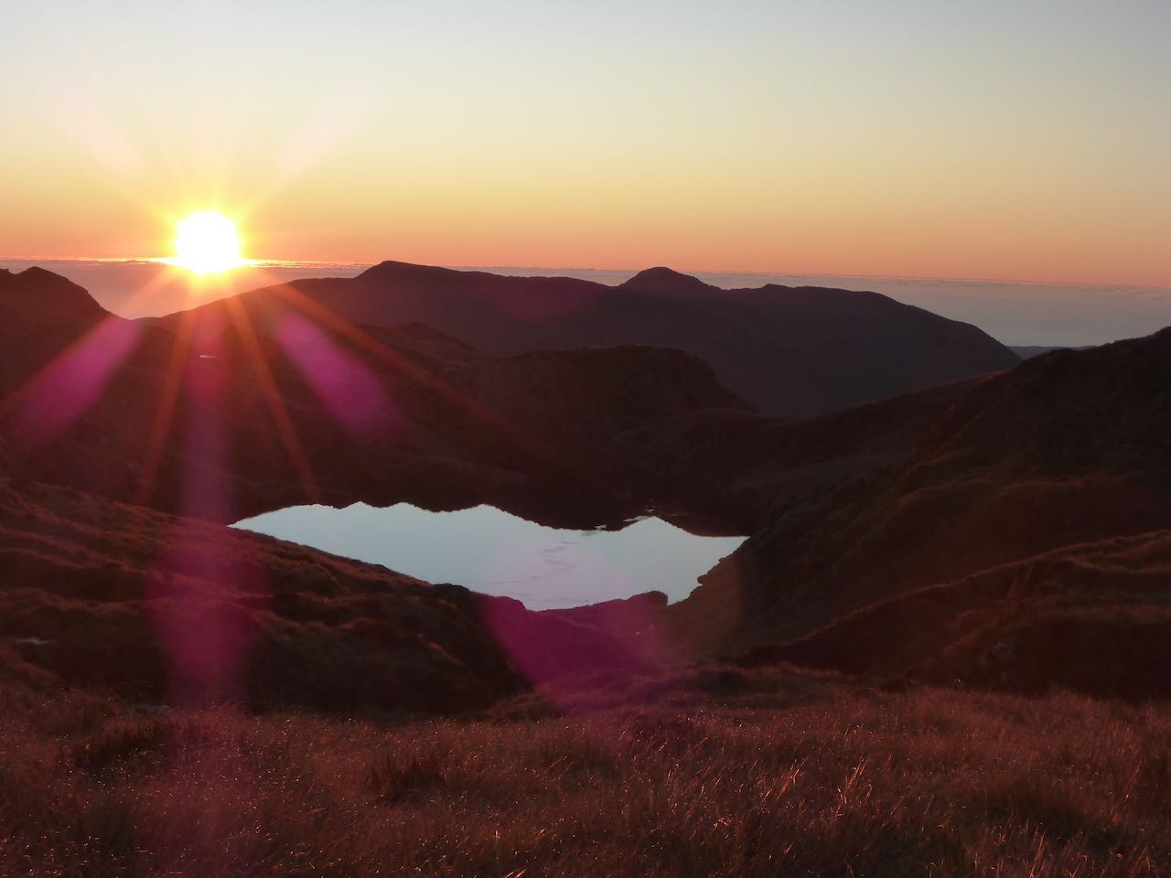
valley on our left that led to twin lakes and camped on a rise just before the
further one. There was a lovely alpenglow as the sun melted into purple clouds
on the far western horizon. I turned around and the tussock had turned russet
against a silver sky. A bright planet
appeared either Jupiter or Saturn. Later during the night, I went outside and
watch a spectacular display of the Milky Way and the Magellanic clouds to the
east, galaxies frozen in a moment of time in a limitless domain beyond our
comprehension.


We were away before 8.00 am next day climbing up to
peak 1449m overlooking Staircase mountain and the ridge to Dagon. We dropped
down to a col at 1259m and decided it was too far to climb Staircase Mountain
and have enough time to reach a bivvy site under Dagon. So we descended easily down
to the lake to the NE at 840 m. There was about 180m of bush on the TL of the
creek at the bottom that went easily. The valley floor was boggy and we crossed
this to a drier place on the far side where we stopped for lunch.


We wandered up the creek towards Dagon around hill
984m following an amazing deer trail through cliffs on the TL. This led to a
hanging valley with some fractured giant rocks which gave us trouble and beyond
them a frosted bowl which the sun never reached. It was now 3.30 pm and the sun
was retreating up the slopes of Dagon, so we carried on up to a lovely sunny
platform at 1200m where we camped. It was much warmer up there, great views,
and a splendid place to camp.
The plan next morning was to climb to about 1300m and
leave our packs while we ascended Dagon and after returning to sidle up across
a shelf to the north to peak 1478. The gully we followed turned a bit icy
higher up as we made for a pinnacle on the left. Alas, this was not the summit
which was further east. The snow slopes were quite frozen and required care as
we did not have crampons or ice axes. Backing off, we found a snow gulley that
took us easily to the summit. A ceiling of grey cloud obscured the summits
though we could discern the Bonar Glacier cascading into the Waipara.
The descent was straightforward back to the packs as
was the sidle to the north though further on, we ran into very fractured slabs
which were hard going. From peak 1478 we descended to a col linking onto the
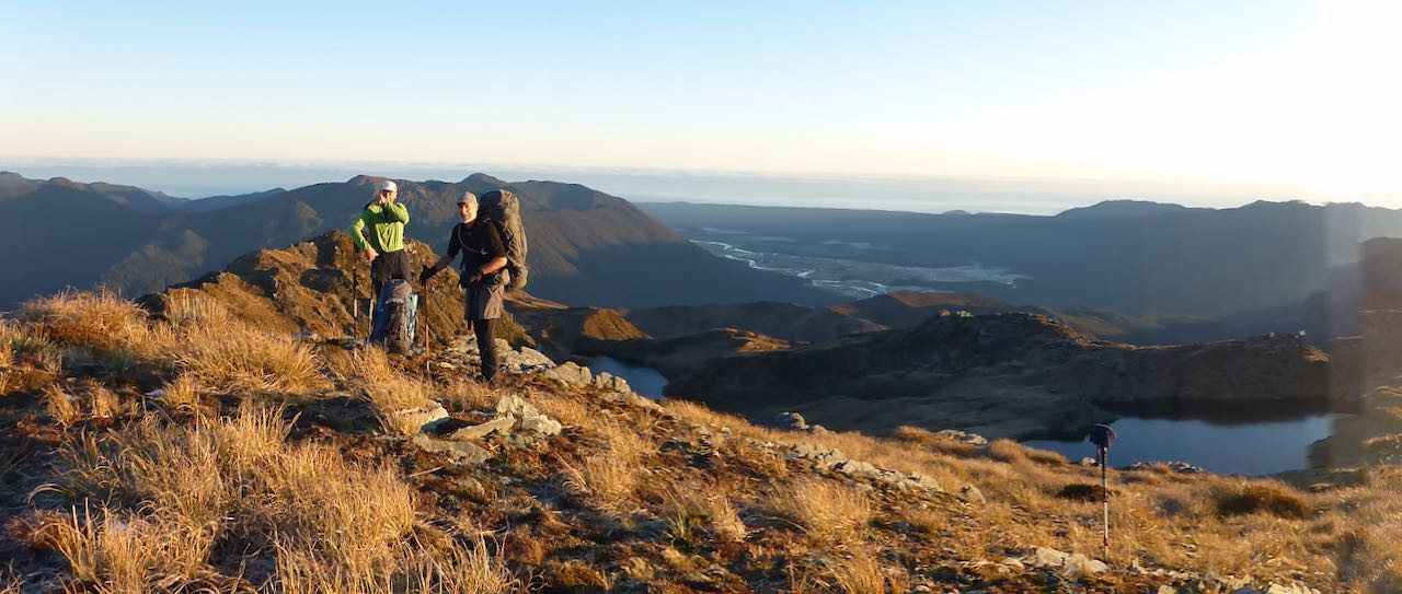
Thomson Range. Below peak 1193, we dropped down to tussock benches to the west
and camped near some tarns. Neil went off to take some photos while we sorted
out our camp and got dinner on before the cold drove us into our tent.


I was up well before dawn firing up the stove and
getting organized. It was just over a kilometre to the bush ridge to Lakes Dan
and Leeb. we followed deer trails along the ridge which was covered in beech
forest with an understory of coprosma. I was plodding along in a desultory
manner when all of a sudden, we came face to face with 2 women trampers coming
in the opposite direction–Frankie and Emily who Neil knew from Hawea. I think
they were just as startled to see us as we were. We swapped our route plans and
I was impressed with their trip and time frame. Then they were gone and we
started climbing up to Lake Dan and just beyond it to Lake Leeb. The sun was
blazing down and it was rather Arcadian especially looking back across the lake
with Mt Aspiring as a backdrop.


We climbed a small hill to Sweetheart Creek and walked
down this to Lake Clarke. On a spur to the west of the outlet, we camped in the
lee of the bush as a frigid wind was blowing from the south. Just across from
us we found a large, wrecked tarp and ropes in the trees likely left by
helicopter assisted hunters– a disappointing sight in such a pristine setting.


The next day, we headed back to the lake, crossing near
the outlet and climbing up the hill on a deer trail to circumvent some deeply
incised vegetated gullies that crossed the flat on the other side. Then we were
at the bush line and following down a bush spur on the TR of Carl Creek to
Moonlight Creek. From here it was in the rocky stream bed, picking our way down
to the Jackson River where we forded just up from the Carl Ck junction. Then
Neil retrieved his bike and briskly sped away to return an hour later with my
car.